I am interested in...
Explore all Golden Bay has to offer....
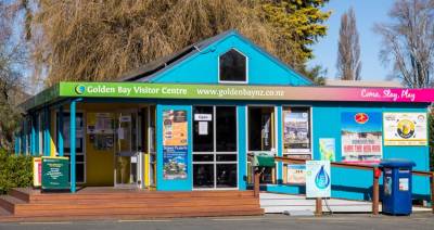
Golden Bay Visitor Centre Opening Hours :
Monday to Friday 10am till 3pm
Kiwibank 10am till 2pm (Mon-Fri)
For all your accommodation, transport and activities in Golden Bay and NZ
Willow Street, Takaka
You have 24/7 access to brochures, maps, activities, providers of accommodation, food and transport outside the Visitor Centre for visitors' use.
45min loop, easy walk, suitable for prams and wheelchairs.
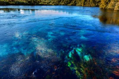
Just 7km from Tākaka township, you will find one of Golden Bay’s most beautiful taonga (treasures). Te Waikoropupū Springs are New Zealand’s largest freshwater springs and the largest coldwater springs in the Southern Hemisphere. Feast your eyes on the clearest water you’ve ever seen, bubbling out of the earth at 14,000 litres per second, dancing with light to create shimmering turquoise hues.
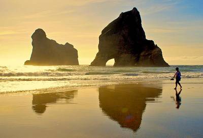
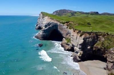
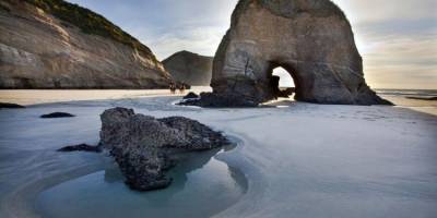
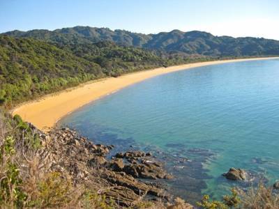
Wharariki is not a safe swimming beach, with its strong currents and wild seas. But it is a fantastic place to spend a day, running down the huge sand dunes, exploring the caves, and at the right time of year you can watch baby seals splashing in the rock pools.
NOTE: The Heaphy Track is currently closed between Heaphy Hut and James Mackay Hut because of severe damage to three bridges and is expected to remain closed until October 2023. See DOC website for more information.
Difficulty:Grade 4 (Advanced).
Time/distance: 2-3 days, 78.4km.
Between the 1st of May and September 30th, you can bike the Heaphy Track, and enjoy the amazing scenery on offer. From nikau palms to lush green forest and even the wild west coast beaches.
Difficulty: Grade 3-4 (Intermediate-Advanced)
Time/distance:3-hour loop, 18.5km.
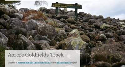
About 7km inland from Collingwood, turn off main road at the Devil’s Boots, and follow the rough road another 2km to Aorere Goldfields carpark. The main loop takes around 2-3 hours, and a shorter loop of Druggans Dam takes 1.5-2 hours. Give yourself extra time to explore the caves (bring a torch!) and the dam. For more information, see the DOC website and the Golden Bay Mountain Bike Club website.
Difficulty: Grade 2-3 (Easy-Intermediate)
Time/distance: From 45 min to 3-hours return, up to 10km.
Drive about 50min from Tākaka to Farewell Spit. From the base of the spit all the way down to Wharariki Beach there are a variety of walks, rides, and lookout points. You have a couple of options for mountain biking. Take the track along Old Man Range to the Pillar Point Lighthouse, continuing down the 4WD track to Wharariki Road, back to your car, or try Green Hills route to Green Hills stream.
Expert route, 5+ hours one way, 1249m ascent.
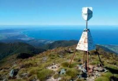
Access is via Ward-Holmes Road just past Puramahoi, before Collingwood. This full-day hike is for fit and experienced trampers, with the entire trip taking 8-10 hours. The challenging climb crosses rocky riverbeds,through shady beech and rātā forest and up to alpine scrub and a ridge top. From the summit trig, expansive views of Golden Bay and beyond await. Bring plenty of water and time check at the halfway point, to make sure you have enough time.
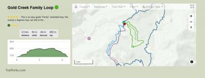
Technical Difficulty: Main Loop (Grade 3) Family Loop (Grade 2-3)
Physical Difficulty: Reasonable level of fitness required for main loop. Lots of scope for family groups and less fit riders as well Times: Full Loop of 14.5km takes about 1.5 - 2 hours. The Family Loop of 5km takes about 30 mins - 1 hour for a family group.

Renowned in the rock-climbing world for its impressive limestone crag, this scenic reserve runs from a carpark and picnic area just off SH60 beside the Paines Ford bridge, along the line of an old railway used to transport timber from the valley down to the Waitapu Wharf. You will find stunning swimming holes, picnic areas, and passionate rock climbers. A cycleway now also connects from Tākaka township through the reserve and on to East Tākaka Road. Return via East Tākaka Road, through Tākaka
5 min to cemetery, with option for longer walk back to Pōhara beach.
A peaceful and shady place for a wander and picnic, perfect for small children. This historic cemetery is a site of great significance for Māori and Pakeha, with upwards of 150 people buried in both marked and unmarked graves, in amongst the trees. Located at the western end of a low-lying sandspit across the Motupipi Estuary, the council reserve is also home to the Tākaka Golf Course, with a walking/cycle trail.

Warm and relaxing, pleasantly-appointed modern motel apartments at the entrance to Takaka township. Pastoral setting, full kitchenettes, free unlimited internet.
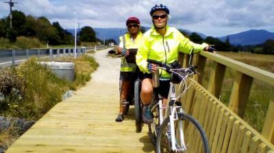
For a reasonably easy ride, try the cycleway from Tākaka to Pōhara, with its recently opened Christine Pullar Bridge over the Motupipi River. A leisurely ride for around 8km alongside Abel Tasman Drive until you reach Pōhara’s vast tidal beach, a perfect place to stop for an icecream. Carry on road biking along the coast beyond, or return the same way via the cycleway to Tākaka.

Up to 1-hour, easy walk.
Just 2km from Tākaka township on the way to Pōhara, this natural maze of paths through karst limestone rock formations and native bush is perfect for little kids. They can go on a scavenger hunt of sorts, as there are toys and figurines placed in nooks and crannies along the way for them to find. Pick up a map at the entrance or let yourself get a little lost; you can spend as little or as long as you like in here. Perfect for if you’d like a little stroll.
30 min one-way, easy walk.
Renowned in the rock-climbing world for its impressive limestone crag, this scenic reserve runs from a carpark and picnic area just off SH60 beside the Paines Ford bridge, along the line of an old railway used to transport timber from the valley down to the Waitapu Wharf, between the early 1880s and 1905. You will find stunning swimming holes, picnic areas, and passionate rock climbers.

20 min to lookout, easy to moderate loop walk.
On your way to Pōhara, turn right onto Clifton Road and follow the signs to the scenic reserve, with a carpark, picnic area and toilet. Step out of time and into a peaceful fairy forest of towering nīkau palms,statuesque northern rātātrees seemingly dripping roots down limestone rocks and water-formed ancient canyons. Follow the path one of two ways to reach a towering outcrop and lookout jutting from the rock face, overlooking farmland and sea.
Easy to moderate walk, 20 min one way to beach (allow half a day or more)
One hour drive from Tākaka, at the northwest tip of the South Island, Wharariki Beach is now world famous and our worst kept secret. Follow the signposts up and across farmland, through a patch of hardy coastal manuka forest, to reach the top of the dunes.
Difficulty: Grade 2-3 (Easy-Intermediate).
Time/distance: 10km of trails.
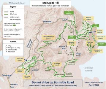
Park your car at Cassidy’s Corner (corner of Abel Tasman Drive and Rototai Road) and follow the new roadside cycleway over the Motupipi cycle bridge, turning left onto Burnside Road. Follow the road to its end and on to a farm track, look for the signposted gate. A network of easy, flowy trails suitable for the whole family with a mix of riding abilities, or those who would like an easy ride away from the roads.

Walks ranging from easy 5 min to more advanced 5 hours.
You can easily spend a day or three exploring this remarkable area. Choose from shorter walks suitable for children, or day-long trips up over bluffs and farmland. Farewell Spit (Onetahua) is a fascinating landscape shaped by wind and water, with ocean currents carrying sediment up the coast before depositing it to form the 25km-long sandspit.
Difficulty:Grade 3-4 (Intermediate-Advanced).
Time/distance: 1-2 hours, 6km (DOC section only).
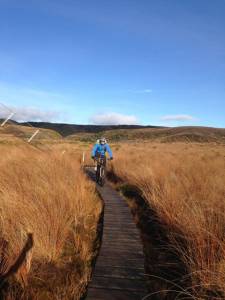
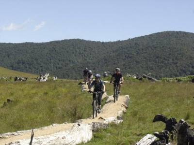
Access is from the carpark at the end of Canaan Road. The signposted track starts 10mins up from the carpark on Pages Saddle. The first 5km rolls gently down through beech forest, then expect rocky sections, some creek crossings, and a much steeper final descent. From the end of the DOC section, take the mountain bike tracks created by Golden Bay Mountain Bike Club and Project Rameka: The Pack Track
Easy walk, 30 min return.
On the way from Tākaka to Collingwood, just before you stop at the renowned Mussel Inn to slake your thirst, stop to stretch your legs in this peaceful patch of forest. You may be able to spot some of the many species of native orchid in the bush, as well as the traps laid out for predators (look but please don’t touch).
As would be expected when walking to a lookout the 1.5 hours to the top of he hill is a lot of "up", but the view is worth it. 360 degrees that take in all of Whanganui (Westhaven) Inlet and miles of the Kahurangi National Park. You can even see Farewell Spit in the distance. The first and last hour of the walk are shared with the Kaituna Track, the Knuckle Hill walk branches off, and from that point is a steep and rocky trek to the top.

Easy walk, from 5 min to 3 hours.
Suitable for the whole family plus the dog (kept under control), there are multiple access points to these sprawling trails through regenerating forest, swamps and lagoons, all fringed by a peaceful beach and estuary. Pick up a map from one of the boxes, make a donation if you are able, and consider returning the map for others once you are finished. The tracks are mostly flat with a few rises and tree roots,they are not not suitable for wheelchairs or prams.
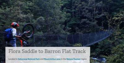
Technical Difficulty: Flora Track (Grade 2-3) Baron Flat Track (Grade 4) 4X4 Road (Grade 2)
Physical Difficulty: Very Good level of fitness required. You must be able to carry your bike on numerous occasions.
Times: The full ride from Flora Carpark to Upper Takaka is 45.5km and will take about 4.5 - 6.5 hours, depending on fitness and track condition.
This popular 3 or 4 day hike wanders along the top of the South Island of New Zealand between blue seas and the green, tree-clad hills.
Abel Tasman Coastal Track is unique among New Zealand's walking tracks in that its 46 km traverse only sea, the bays, cliffs, estuaries and sea hills of Abel Tasman National Park, the entire unroaded coastline between Tasman and Golden Bay.
Easy 5 min walk.
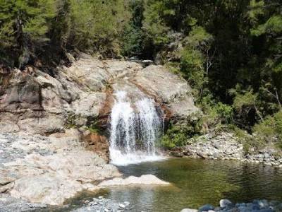
Drive 30 min inland from Collingwood towards the Heaphy Track, stopping to grab a coffee and cake at the historic Langford Store,then follow the signs to this little gem. Park on the side of the road, cross a fence stile or two, and within minutes you are at the cascading waterfall and its inviting swimming hole. Just down from the falls is the Aorere River, with its deep waters and interesting rock formations forming a stunning gorge
Difficulty: Grade 3 (Intermediate)
Time/dist: 2.5 hrs, 23km.
Mountain biking the Wainui-Gibbs Hill-Tōtaranui loop is allowed from 1 May - 30 Sept. From Wainui carpark, follow the coast track to the saddle, take a right up the ridge to Gibbs Hill – very steep. Follow the ridge south until you turn left toward Tōtaranui. Return to Wainui via the gravel road, 13km. Alternatively, drive to Tōtaranui, and bike from there toward Anapai Bay, turning left onto the Gibbs Hill Track,returning the same way

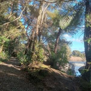
Wainui Bay marks the start of the Abel Tasman National Park and is bursting with beauty, also offering multiple walking tracks, including the short hikes to Wainui Falls, or out to Taupo Point.

Moderate to expert walks, from 2 hours one way, up to multi-day walks.
The Cobb River and its glacial valley are nestled in the Kahurangi National Park. From the Golden Bay side of the Tākaka Hill, a narrow 28km road leads up to the Cobb Reservoir (4WD recommended in winter, check for any road closures in bad weather). From the reservoir and lookout, you can drive down to the end of the road at Trilobite Hut and nearby campsite. A multitude of walks are on offer from there.
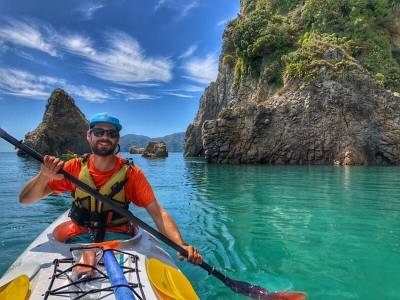
Gateway to the northern end of the Abel Tasman National Park. Islands, rock formations and an abundance of wildlife. Guided tours, family tours, freedom rentals and stand up paddle board hire.
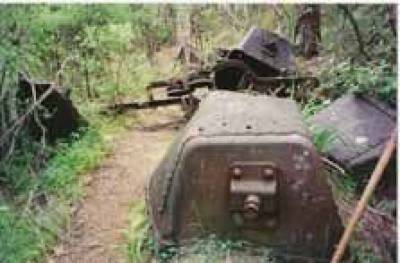
There are several places in Golden Bay where miners' tracks built last century are being enthusiastically re-used by today's visitors. Turn off the main road at Kaituna Bridge and follow the signs to the modest carpark near the bush edge. From here a well-graded track takes you first to the old Kaituna gold-workings, where water-races, shafts, stacked stones and the odd piece of rusting iron identify a hundred-year-old rush; then the track carries you further into the hills with splendid views o
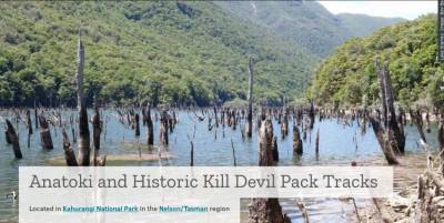
Difficulty: Grade 4-5 (Advanced-Expert).
Time/distance: 1-2 days, 37.4 km return via same track.
Park at the end of Uruwhenua Road, 17km south of Tākaka. Plan for one full day of intense riding or stay overnight at either Riordans Hut or Waingaro Forks Hut. A technically challenging ride on rough terrain, with the ascent up Kill Devil Spur including 58 switchbacks. For more information, see the DOC website and the Golden Bay Mountain Bike Club website.
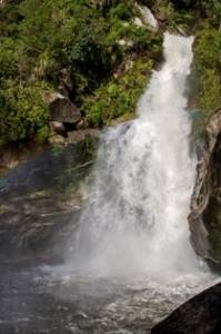
30 min, easy to moderate walk to waterfall, 1-hour return trip.
Look for the signposted carpark in Wainui Bay, 20km northeast of Takaka. You will cross a short section of farmland (and one unbridged stream crossing) before entering a forest of nīkau palms, rātā trees and ferns. Winding up the Wainui river in a steady but accessible climb, you will cross a swingbridge over the river just before reaching the waterfall. Keep children close by due to steep drops.
Difficulty: Grade 2 (Easy).
Time/distance: 30 min, 4.6km.
Starting at the Canaan Downs car park, this enjoyable family ride loops through farmland and beech forest, with a gravelled track making it suitable year-round. Take the track clockwise, taking a left once you pass through the gate. There are two creek crossings so be prepared to get wet feet. For more information, see the DOC website and the Golden Bay Mountain Bike Club website.


Nelson Tasman Tourism App
© Golden Bay Promotions Association